
 Earth & Space
The breathing and fate of a rock slope
Sliding and collapses of rock slopes may represent a potential threat for infrastructure and populations living nearby. Measuring their movements and understanding their dynamics can reveal crucial information for assessing risk and prevent devastating events.
In mountainous regions, large sections of rocks slopes can be unstable and potentially collapse leading to catastrophic events where people and infrastructure are exposed. In most cases, movements affect the slope prior to the failure and can thus be measured to assess the hazard and monitor the area. The characterization of the spatial distribution and temporal evolution of the displacements is fundamental to understand the behavior of unstable slopes, score the hazard, and forecast potential collapse events.
Various tools and instruments are used to measure displacement rates on rock slopes. Some of them, such as Global Positioning Systems devices (GPS), provide three-dimensional and high-accuracy measurements but only at specific points, leading to a sparse spatial coverage of the area of interest. For the last decades, the development of remote sensing techniques, from aircrafts, spacecrafts or remotely ground-based systems, contribute to overcoming this problem. They have had a major impact in the field of geohazards monitoring, due to large coverage capability, high resolution and ability to document areas difficult to access. One of these remote-sensing systems is the ground-based imaging radar. Set-up at several kilometers from the rock slope, the radar sends microwaves. The signal hits the ground and the echoes back to the radar are recorded. Using a technique called Synthetic Aperture Radar Interferometry (InSAR), we can compare the images acquired at a minute-scale and provide continuous information about the ground displacements over the scanned area at a sub-millimeter accuracy. The displacements are one-dimensional along the line-of-sight of the radar, corresponding to variations of distance between the imaged area and the sensor.
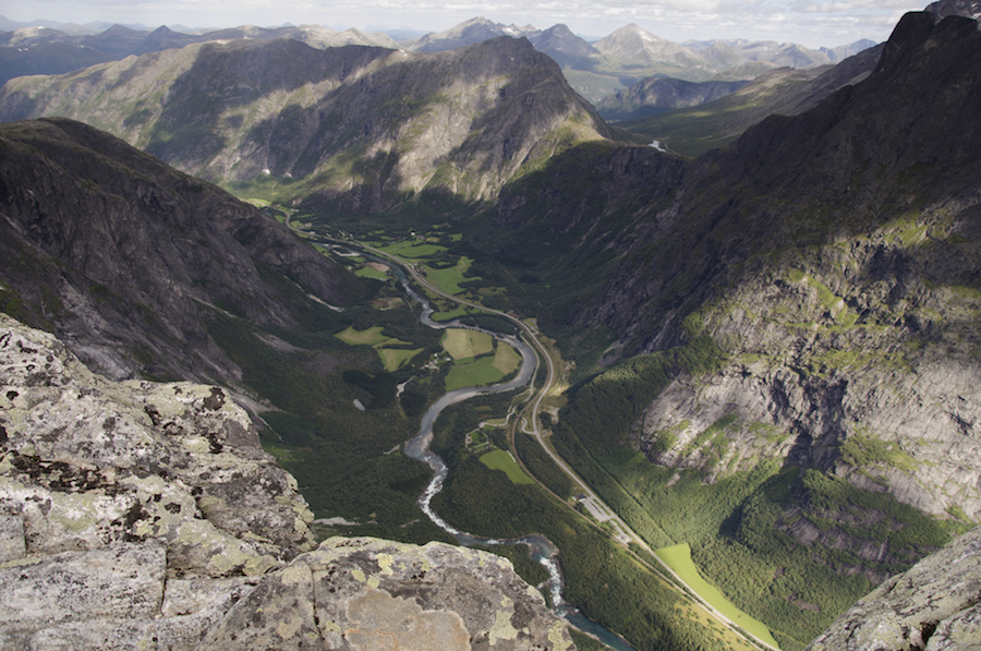
In our study, we used a ground-based imaging radar to monitor the Mannen/Børa rock slope in western Norway. Located on the side of the inhabited Romsdalen valley in Rauma Municipality (Møre & Romsdal county), Mannen is an active rockslide threating houses, roads, and a railway track. Mannen has been scored as a high-risk rockslide and is thus monitored continuously using several measurement devices including a ground-based imaging radar since 2010. In summers 2011 and 2012, in order to enlarge the scanned area and check the stability of sectors outside the main moving zone, a second ground-based imaging radar has been installed. Together, the two radars imaged a 3 km wide section of the slope with a valuable overlap in the middle that contributes to cross-check the results. Thanks to it, we discovered an area affected by 5-10 mm inflation/deflation phenomenon. The rock slope is breathing! By analyzing several years of ground-based data, we highlighted that the pattern is not homogeneous in time and inversions have a seasonal recurrence: the slope inflates at the beginning of the thawing season and deflates during the summer. The movement inversion occurs between June and July. The assumption to explain the rock slope breathing phenomenon is that the area is subjected to large variations of groundwater pressure. At the beginning of the thawing season, pressure increases due to high water infiltration and residual ice in fractures. This leads to rock slope inflation. During the summer, the water inputs decrease and residual ice melts. Water evacuates and desaturates the slope which leads to deflation.
The research contributes to evidence seasonal inversions of movements of a rock slope, so-called rock slope breathing. These small variations are often ignored or undervalued in the analysis and monitoring of large and fast rockslides threating population and infrastructure. They are however important to take into account a complete understanding of a rock slope behavior. It has been indeed shown that even if the magnitude is small, a regular hydro-mechanical stress can fatigue and damage the rock mass at long-term. In addition, our study highlights the valuable contribution of remote sensing techniques to detect, map and monitor small-scale movement fluctuations in natural slopes.
Original Article:
L. Rouyet et al., Evidence of rock slope breathing using ground-based InSAR. Geomorphology 289, 152-169 (2017)Edited by:
Massimo Caine , Founder and Director
We thought you might like
Gene edited “superpigs” resist devastating disease
Feb 13, 2019 in Health & Physiology | 4.5 min read by Christine BurkardThe Impact of SARS-CoV-2 on the Brain: It Is All in Your Head
Feb 15, 2023 in Neurobiology | 3.5 min read by Meredith G. Mayer , Tracy FischerHow nanosized shrapnel from exploding fungal cells may impact us: from allergies to cloud formation
Nov 5, 2020 in Microbiology | 3.5 min read by Michael J. LawlerExtending the genomic record of human diversity
Mar 25, 2021 in Evolution & Behaviour | 4 min read by Anders BergströmMore from Earth & Space
Discovery of the first radiation belt beyond the Solar System
Jan 27, 2025 in Earth & Space | 3.5 min read by Juan Bautista Climent OliverOne million (paper) satellites
Jan 24, 2025 in Earth & Space | 3 min read by Ewan Wright , Andrew FalleVolcanic Ash: A Nutrient Boost for Reef-Building Corals
Sep 18, 2024 in Earth & Space | 4 min read by Frank Förster , Tom SheldrakeAmmonia Energy: A Call for Environmental Awareness
Aug 29, 2024 in Earth & Space | 3.5 min read by Matteo Bertagni , Robert Socolow , Amilcare PorporatoLikely increase in coral thermal tolerance at a Pacific archipelago
Dec 29, 2023 in Earth & Space | 3 min read by Liam LachsEditor's picks
Trending now
Popular topics